


Washington is home to more than two dozen scenic byways, including the 92-mile Stevens Pass Greenway that extends through Snohomish County from the city of Monroe, nearly 50 miles west of the pass, to Chelan County’s historic town of Cashmere, 40-plus miles east of the pass.
The Greenway follows U.S. Highway 2 and passes through a dozen small cities and towns nestled below a wild world of craggy mountains rising 5,000 to 6,000 feet above sea level. Countless trails weave through this mountain paradise, some of which can be quite challenging to hike. Backpacking opportunities are virtually endless. The 2,653-mile-long Pacific Crest Trail, leading from Mexico all the way to Canada, crosses the highway at Stevens Pass.
However, all along the Greenway you’ll find excellent options for shorter walks and easy to moderate day hikes that promise quiet getaways, and in some cases big scenic rewards for your effort. Below are some of the shorter walks and hikes between Monroe and Stevens Pass that are well worth breaking in a new pair of walking shoes.
Monroe
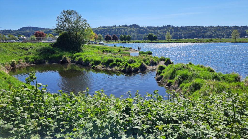
On Fryelands Boulevard just south of SR 2, find Lake Tye Park, where a nearly level 1.7-mile paved loop trail surrounds the artificial lake, playground, picnic shelter, and skate park. The path is open and sunny, and is also stroller, wheelchair, walker, and kid-bike friendly.
Aim for the old center of town near Lewis and Main Streets to explore the historic downtown and visit the historical museum. Or stroll among some giant cottonwood trees near the Skykomish River at Al Borlin Park, which you can access from Lewis Street, a half mile south of Main Street.
Sultan
As you drive into Sultan, notice the big pedestrian bridge over the Sultan River. It connects to Susie’s Trail, which can also be reached from Osprey Park. Turn left at 4th Street and left again at High Street to reach the park and an extensive, hill-free trail system in lush forest near the Sultan River.
Maybe check out the inviting Kiss the Sky bookstore (and occasional live music) at 4th and Main Streets. Continuing on the highway east through town, the little Sultan Bakery on the left is always worth a stop.
Just beyond, the Sultan Basin Road leads 13 miles to Olney Pass with an info kiosk detailing several worthwhile hikes in the area. The kid-friendly Sultan River Canyon and the beauteous Bear Creek Overlook are both great choices.
Gold Bar
Five miles east of Sultan, you’ll find the town of Gold Bar, where the best-known attraction is the moderate hike to Middle Falls at Wallace Falls State Park. Turn north at the park sign at milepost 28. You’ll need a Discover Pass here (available online or at the park).
Or hike to the impressive Sky Valley Vista, about two miles each way on a nicely maintained, not-too-steep trail. The trailhead is off May Creek Road at the north end of 429th Avenue SE.
Index
Just west of Index and south of SR 2 is the ever-popular trail to Bridal Veil Falls and Lake Serene. The upper falls viewpoint and the lake are fairly stiff hikes, with hundreds of wooden and stone steps to negotiate. The lower falls viewpoint is far easier, but still about two miles each way. Reach it from the Mount Index Road at milepost 35.2.
The quiet charm of the tiny mountain town of Index is hard to resist. At milepost 35.6, turn north on the Index-Galena Road, then left over the bridge. Grab an ice cream at the corner market and scan the nearby Index Town Wall for rock climbers. Then walk back out on the bridge for exceptional river and mountain views. Just across the bridge is the trailhead for the easy Erinswood and moderate Heybrook Ridge Trails. Allow 2 to 3 hours to hike them both.
The Index-Galena Road is an adventure in itself. The mostly paved, 30-mile loop winds through the mountains and along the North Fork Skykomish and Beckler Rivers, accessing numerous trails and camping areas. The road rejoins SR 2 just east of Skykomish. Troublesome Creek (easy half-mile loop) and Frog Mountain (moderately strenuous four miles each way) are a couple of author favorites.
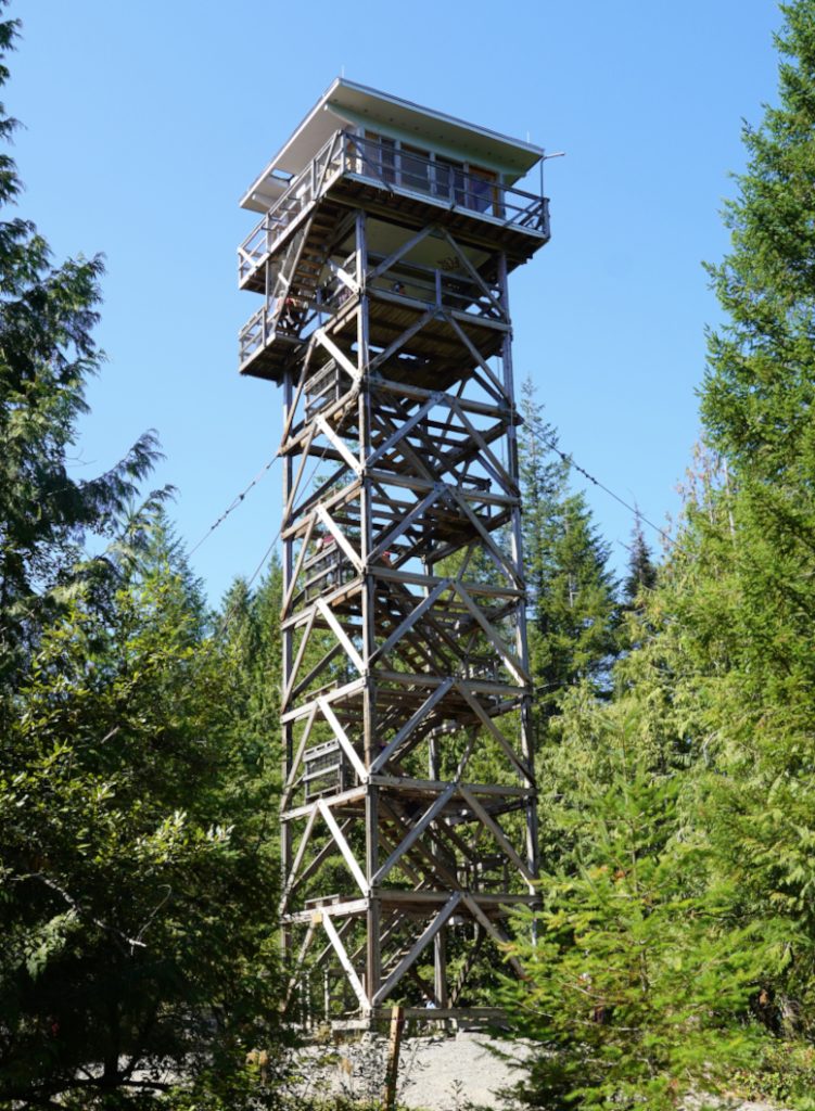
If you backtrack from Index and continue east along the Stevens Pass Greenway, you’ll quickly reach the trailhead for Heybrook Lookout at milepost 37.6. A 900-foot climb in just over a mile brings you to the lookout tower, where your grinding workout is rewarded with a fabulous view.
Two miles past Heybrook is a forest road on the left leading to the trailhead for Barclay Lake. The scenic, two-mile hiking trail to the lake is relatively mellow and family-friendly, making it likely to be super-busy on nice weekends.
Skykomish
At milepost 48.7, turn south for historic Skykomish, a community closely tied to the story of the Great Northern Railroad. Stevens Pass is named for the railroad’s lead engineer, who located the crossing in 1890. A local history museum and historic train station downtown both offer fascinating stories and artifacts from the early days of the railroad. Don’t miss the free, volunteer-run miniature train ride that runs on Saturdays all summer.
Nearby, look for the Maloney Creek Interpretive Trail off the end of Thelma Street. At the big bridge, a short path also leads along the river. Farther east at milepost 52.1, Forest Road 6066 leads seven bumpy miles to the Beckler Peak trailhead. This one is a more ambitious trek of nearly four miles each way, but it leads to dramatic summit views.
Deception Falls
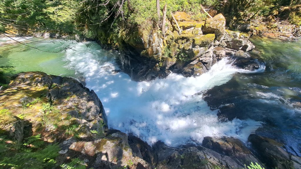
About eight miles east of Skykomish at milepost 56.8, find Deception Falls and one of the best short waterfall hikes around. A half-mile loop passes several impressive falls. Or you can easily snap a photo of the namesake falls from a trail bridge near the parking area.
On the north side of the highway at milepost 58.2, you’ll find the main trailhead for the Iron Goat Trail. Several miles of the original Great Northern Railroad grade, built in the 1890s, were first converted to a trail over 30 years ago, including wheelchair-accessible and loop options. Check the information kiosk for a map and some fascinating history.
Stevens Pass
At the Stevens Pass Ski Resort, you can sample a bit of the Pacific Crest Trail, including the big trail bridge over the highway. For the more interesting section, begin at Parking Lot B or walk south between the ski area buildings and angle leftward up the slope to hit the trail. In two miles, reach a ridge crest with big views. One could continue northeastward on a faint path for a little over a mile, mostly in meadows, all the way to the summit of Big Chief Mountain.
Beyond to Leavenworth
If you’re continuing along the Stevens Pass Greenway to Leavenworth, there are a ton of trails to explore in town and along Icicle Creek. When you’re headed back west, the Bygone Byways Interpretive Trail, a few miles east of Stevens Pass, preserves some unique history and is also worth a quick stop (access from westbound only).
Ken Wilcox has been hiking Snohomish County trails for decades. He is the author of “Hiking Snohomish County—140 Hikes and Walks” from the North Cascades to the Salish Sea, and his newest guide, “Hiking Island County—60 Hikes and Walks” on Whidbey and Camano Islands. The books are available online and at many area bookstores and gift shops.


