


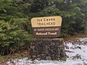
The Big Four Ice Caves in Mount Baker-Snoqualmie National Forest serve as both a beautiful hiking spot and a historical site on the Mountain Loop Highway. Located about four miles east of the town of Silverton, the geologically fascinating Big Four Mountain has long stood as a witness to Snohomish County history.
Big Four Mountain, dubbed by miners that spotted the shape of the number four on the mountain’s snowy face, is a 6,135-foot peak nestled in the heart of the Mount Baker-Snoqualmie National Forest. As part of the Cascade Mountain Range, Big Four Mountain is composed of sedimentary rock carved out by glaciers and stacked by the shifting of tectonic plates over millions of years. Although no glaciers remain on Big Four Mountain today, voluminous and consistent annual snowfall has contributed to the formation of the ice caves found at the mountain’s base.
Avalanches are a common occurrence on the mountain, as evidenced by the fields of broken trees lying at the foot of Big Four. Icy rubble from the repeated avalanches formed huge mounds at the base of the mountain subjected to a constant cycle of melting and re-freezing, resulting in the formation of the unique ice cave structures. The caves continually form and fall apart, making the ice caves a beautiful yet dangerous natural attraction. Thousands of pounds of ice and snow can collapse at any moment, making for impressive views best observed from the safe distance indicated by the well-established walking paths.
The 2.2-mile roundtrip hiking route starts on the same walkways once used by visitors to the historic Big 4 Inn. Built in 1921 by lumber barons and Everett founders Bethel and Wyatt Rucker, the inn was constructed to increase tourist traffic on the Monte Cristo Railway, which the Ruckers also operated at that time. The inn became a popular vacation spot despite its remote location. A generator powered by a water turbine in proximal Perry Creek provided electricity to the inn so guests could explore the nearby wilderness while enjoying the creature comforts and cultural events at the inn. One busy season saw over 6,000 visitors to the 35-room inn.
Although the inn was prosperous, recurrent issues with the railway began to take a toll. Bridge washouts, landslides, floods, and avalanches caused frequent railway closures, and the Ruckers eventually sold the railway and the inn during the summer of 1929 to the Puget Sound Pulp and Timber Company. The inn did remain open during the Great Depression and saw a short upswing in business upon the opening of the Mountain Loop Highway in 1938, but its most successful days were far behind. In September of 1949, the inn burned to the ground and all that remains of it today is the lobby’s large stone fireplace. Today, visitors to the ice caves trail experience a grand view of the fireplace with Big Four Mountain looming large in the background.
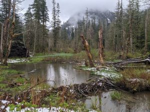
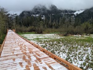
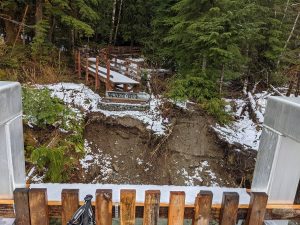
With the inn gone, the area has mostly returned to marshland. The wetlands provide an abundant bird-watching site, and depending on the season, visitors can also spot muskrats, salamanders, frogs, and juvenile salmon. Beaver dams and lodges are seen on the stretch of Mountain Loop Highway leading to the Big Four recreational areas, and a beaver lodge now occupies some of the land where the inn once stood. A wooden boardwalk allows hikers to traverse this soggy section before the trail turns into a forested path that terminates at a closed bridge. This bridge used to cross the south fork of the Stillaguamish River, but the section over the river was recently removed for repairs.
For now, visitors can still see the ice caves from the southern entrance to the trail, which lies adjacent to the inn’s old fireplace. The northern access to the trail leads hikers through a densely forested area that contains part of the former railway grade. A mere 220 feet of elevation gain make for an easy hike from both entrances. Informational signs and billboards are found at each entrance, and a Northwest Forest Pass is required to park in either area. Group and single-site campgrounds and dispersed campsites can be located all along the Mountain Loop Highway to the east and west of the Big Four area.
Hikers working their way through Mount Baker-Snoqualmie National Forest and day-trippers or campers looking for an educational destination will enjoy the raw beauty of the Big Four Ice Caves. Whether hoping to observe local wildlife or searching for awe-inspiring landscapes, visitors to the foot of Big Four Mountain will find it a rewarding destination.


